Collins Children’s World Wall Map : An Illustrated Poster for Your Wall
2 Revised edition
by
Collins Kids
Book Details
Format
Sheet Map, Rolled
ISBN-10
0008319790
ISBN-13
9780008319793
Edition
2 Revised edition
Publisher
HarperCollins Publishers
Imprint
Collins
Country of Manufacture
MY
Country of Publication
GB
Publication Date
May 16th, 2019
Print length
1 Pages
Weight
96 grams
Dimensions
91.70 x 3.00 x 3.00 cms
Product Classification:
Educational: GeographyAtlases & maps (Children’s/Teenage)
Ksh 1,250.00
Werezi Extended Catalogue
Delivery in 14 days
33 copies in stock
Delivery Location
Delivery fee: Select location
Delivery in 14 days
Secure
Quality
Fast
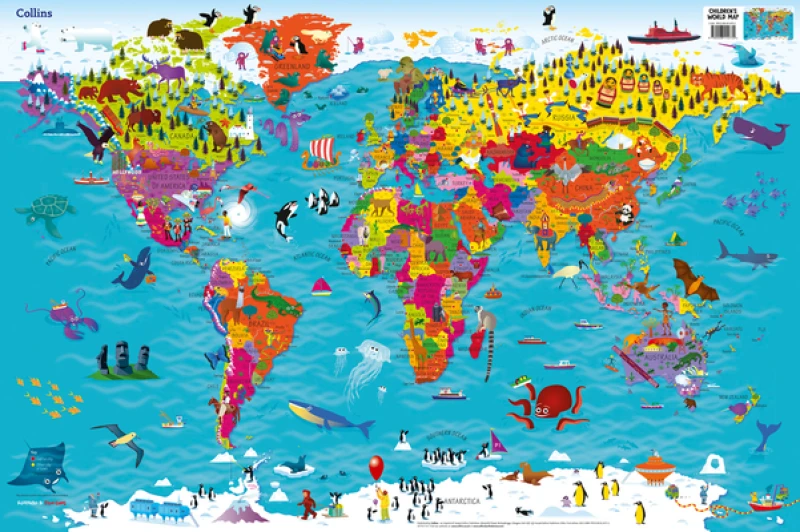
Beautifully illustrated wall map for inquisitive kids Colourful Illustrated Map of the World
Beautifully illustrated wall map for inquisitive kidsColourful Illustrated Map of the WorldThis bestselling, highly illustrated pictorial map is designed to take children on a journey of discovery around the countries of the world. The mapping is up-to-date, colourful and highly informative and shows countries and capital cities.Stunning illustrations are used to depict themes such as national emblems, customs, food, birds, animals, buildings and sports to help younger readers gain an understanding of the world.Dimensions 610 X 915 mm / 24 x 36 inchesIllustrated by Steve Evans.Now with barcode removed due to popular demand from our customers.
Get Collins Children’s World Wall Map by at the best price and quality guaranteed only at Werezi Africa's largest book ecommerce store. The book was published by HarperCollins Publishers and it has pages.

