
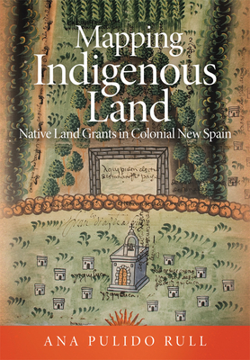
Mapping Indigenous Land : Native Land Grants in Colonial New Spain
Book Details
Format
Hardback
ISBN-10
0806164964
ISBN-13
9780806164960
Publisher
University of Oklahoma Press
Imprint
University of Oklahoma Press
Country of Manufacture
US
Country of Publication
GB
Publication Date
May 28th, 2020
Print length
264 Pages
Weight
765 grams
Dimensions
25.90 x 19.30 x 2.20 cms
KSh 6,750.00
Currently unavailable
0 in stock
Delivery Location
Delivery fee: Select location
Secure
Quality
Fast
Between 1536 and 1601, at the request of the colonial administration of New Spain, indigenous artists crafted more than two hundred maps to be used as evidence in litigation over the allocation of land. This book explores how, as persuasive and rhetorical images, these maps did more than simply record the disputed territories for lawsuits.
Between 1536 and 1601, at the request of the colonial administration of New Spain, indigenous artists crafted more than two hundred maps to be used as evidence in litigation over the allocation of land. These land grant maps, or mapas de mercedes de tierras, recorded the boundaries of cities, provinces, towns, and places; they made note of markers and ownership, and, at times, the extent and measurement of each field in a territory, along with the names of those who worked it. With their corresponding case files, these maps tell the stories of hundreds of natives and Spaniards who engaged in legal proceedings either to request land, to oppose a petition, or to negotiate its terms. Mapping Indigenous Land explores how, as persuasive and rhetorical images, these maps did more than simply record the disputed territories for lawsuits. They also enabled indigenous communities - and sometimes Spanish petitioners - to translate their ideas about contested spaces into visual form; offered arguments for the defense of these spaces; and in some cases even helped protect indigenous land against harmful requests.
Drawing on her own paleography and transcription of case files, author Ana Pulido Rull shows how much these maps can tell us about the artists who participated in the lawsuits and about indigenous views of the contested lands. Considering the mapas de mercedes de tierras as sites of cross-cultural communication between natives and Spaniards, Pulido Rull also offers an analysis of Medieval and Modern Castilian law, its application in colonial New Spain, and the possibilities it opened for the native population.
An important contribution to the literature on Mexico's indigenous cartography and colonial art, Pulido Rull's work suggests new ways of understanding how colonial space itself was contested, negotiated, and defined.
Drawing on her own paleography and transcription of case files, author Ana Pulido Rull shows how much these maps can tell us about the artists who participated in the lawsuits and about indigenous views of the contested lands. Considering the mapas de mercedes de tierras as sites of cross-cultural communication between natives and Spaniards, Pulido Rull also offers an analysis of Medieval and Modern Castilian law, its application in colonial New Spain, and the possibilities it opened for the native population.
An important contribution to the literature on Mexico's indigenous cartography and colonial art, Pulido Rull's work suggests new ways of understanding how colonial space itself was contested, negotiated, and defined.
Get Mapping Indigenous Land by Ana Pulido Rull at the best price and quality guaranteed only at Werezi Africa's largest book ecommerce store. The book was published by University of Oklahoma Press and it has 264 pages.
Customers Who Bought This Also Bought

World According to Colour
KSh 2,700.00

The Metropolitan Museum of Art
KSh 13,350.00

The Story of Art
KSh 4,500.00

Artists Who Changed History
KSh 5,900.00

Fashion
KSh 7,800.00

Art
KSh 9,250.00

Story of Art without Men
KSh 2,900.00
Tao Te Ching
KSh 3,050.00

The Invention of Design
KSh 4,500.00

Letters to a Young Painter
KSh 1,950.00
The Jean–Michel Basquiat Reader – Writings, Interviews, and Critical Responses
KSh 14,400.00
Basquiat–isms
KSh 2,350.00
